Upper Mustang Tours and Travels
Kanchenjunga base camp trek from Nepal
Trip Overview
About Kanchenjunga base camp trekking
Mount Kanchenjunga base camp trek Nepal is a real off-the-beaten-path adventure into the soul of Himalayas. It’s a chance to disconnect from the modern world and immerse yourself in the raw beauty of Nepal. KBC trail passes through the remote villages inhabited by Limbu, Rai, Sherpa, and Tibetan communities of eastern Nepal. Along the way, you’ll have the opportunity to experience their unique traditions, hospitality, and way of life.
Kanchenjunga trekking offers an amazing view of pristine landscapes, diverse flora and fauna, rich cultural heritage and a true sense of wilderness. And of course, the views of Kanchenjunga and its neighboring peaks are simply jaw-dropping. This means you’ll encounter unspoiled trails, tranquil landscapes and a sense of solitude that is hard to find elsewhere.
There are two major routes to explore the base camp of world’s third-highest peak, Mount Kanchenjunga Nepal (8,586 meters). We offer trek to KBC covering both North Base Camp (Pangpema, 5,143 m) and South Base Camp (Oktang, 4,730 m). The sight of these giants glowing with sunrise is nothing short of magical and the ultimate reward for your efforts and a moment you’ll cherish forever.
Trip Highlight
- Reach the base camp of Mt. Kanchenjunga 8,586 m / 28,169 feet, the third highest peak of the world.
- Encounter verity of flora, fauna and birds on natural habitat in Kanchenjunga conservation area.
- Explore Deurali, Temples, Monasteries, Mani walls, Prayer flags and Chortens on the way to KBC route.
- Visit Kanchenjunga north base camp at 5,140 m & south base camp at 4,610m crossing Sele la, Mirgin la, Sinelapche pass.
- Witness the unspoiled nature, waterfall, amazing landscapes, lush forests, rivers, vibrant hamlets and terraced farmlands.
- Interact with local ethnic groups of people like Rai, Limbu and Sherpa, know their culture, tradition & way of life.
- Get the glimpse of rural Nepal, Kanchenjunga glacier, Yalung glacier, glacial lakes and Tibetan refugee camp in Taplejung.
- Feel the peace and tranquility during Kanchenjunga base camp journey on off the beaten path in eastern Nepal.
- Witness wonderful view of Kanchenjunga massif, Yalung Kang, Kangbachen, Mount Kumbhakarna, Kabru and many other peaks of Himalayas.
Detailed Itinerary
- Day 1 : Arrival day in Kathmandu, Nepal
Upon arrival at Tribhuvan International Airport in Kathmandu, you will be met by our representative and transfer you to hotel. As soon as we reach hotel, representative will give you a synopsis of plan and program agreement. After a short rest & relax, you can explore the city and its cultural heritage.
Elevation: 1,400 meters / 4593 feet. - Day 2 : Flight to Bhadrapur then drive to Ilam
The first day of adventure start with morning flight from Kathmandu to Bhadrapur. It takes around 45 minutes to reach Bhadrapur airport. From Bhadrapur guide arrange private vehicle to go to Ilam Nepal. Road distance from Bhadrapur to Ilam is about 84 kilometers / 52 miles. It takes about 3/5 hours to reach Ilam by driving in Mechi highway. Along the road you will get an opportunity to see many tea estates, villages, rolling green hills and great mountain view including Mt. Makalu and Kanchenjunga etc. Drive from Bhadrapur to Ilam is relatively easy because the road is paved and in good condition but winding through hills. We advise all to prepare for motion sickness. Ilam is famous for its lush tea gardens.
- Day 3 : Drive to Taplejung 1820 meters / 5971 feet
The day begins with drive towards Taplejung, the gateway to the Kanchenjunga base camp trek Nepal. Ilam to Taplejung journey is a scenic and exciting. The road is mostly hilly terrain and winding, with mix of paved and gravel roads. Ilam to Taplejung road distance is 152 kilometers / 95 miles in Mechi Highway. It takes 5 to 8 hours depends on road conditions, weather and the mode of transportation. Driving route offer eye-popping landscapes, local people, culture and towering foothills of the Himalayas. This journey pass via Phidim, the headquarters of Panchthar district and finally reach Taplejung “the gateway of Kanchenjunga trek” a small town in eastern Nepal.
- Day 4 : Drive to Sukethum 1650 meters / 5413 feet
After breakfast, we will move towards Sukethum by jeep. The drive from Taplejung to Sukethum in Nepal is a scenic but challenging journey primarily due to rugged terrain and narrow mountain roads, through the Himalayan foothills. Taplejung to Sukethum road distance is 35 kilometers, it takes 3 to 4 hours. As soon as we leave Taplejung jeep descends towards the Tamor river, cross pristine landscapes, small streams and lush forests to enter Kanchenjunga national park.
Finally, we reach Sekathum village at an altitude of 1,650 meters, the KBC trek start point. Taplejung to Sekethum parts offer stunning views of river valley, surrounding hills, terraced fields and ethnic villages like Mitlung, Chhiruwa, Tapethok, Lelep etc. - Day 5 : Trek to Amjilosa 2498 meters / 8195 feet
Sukethum to Amjilosa trek involves steep ascents and descents, river crossing, navigating through dense forests and rocky terrain. Walking trail winds along the Ghunsa Khola, river fed by Kanchenjunga glacier. As you ascend, the air becomes cooler and the views more extensive.
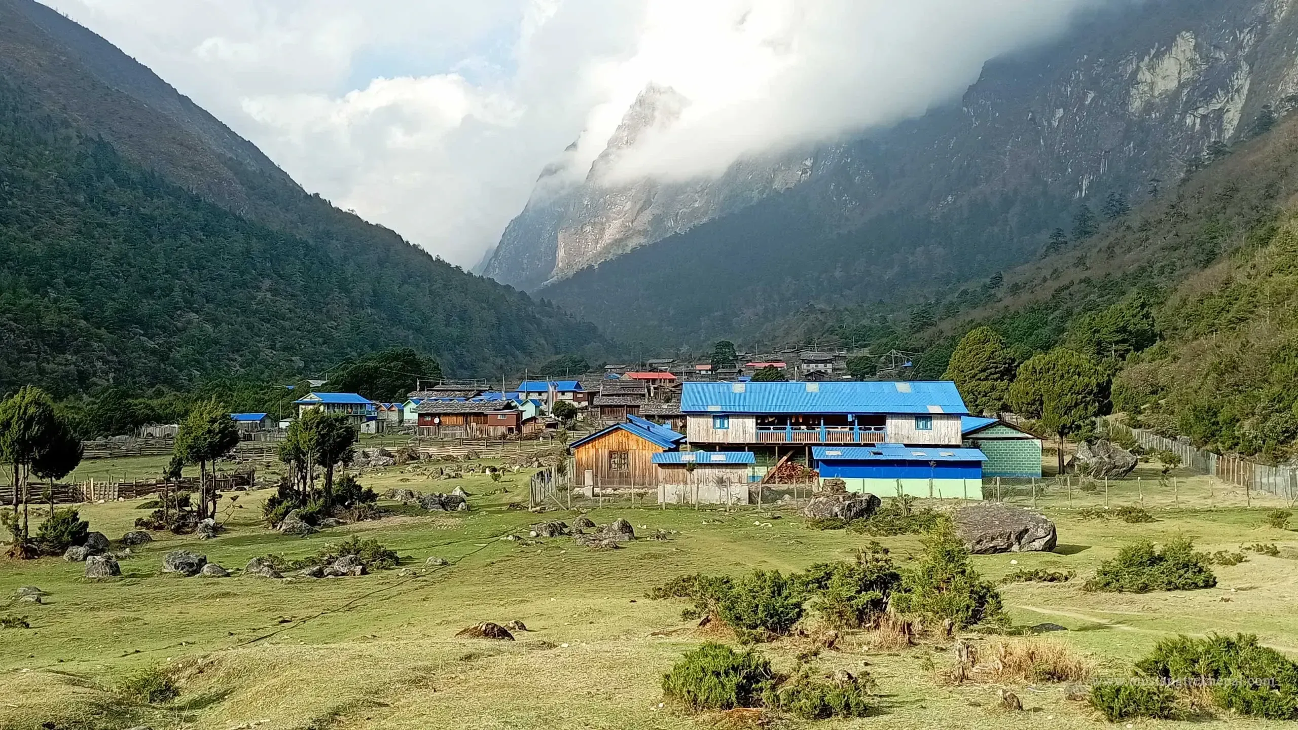
Amjilosa village situated at an altitude of 2498 meters, is home to Tibetan and Sherpa communities. It is one of the best place to insights into the unique culture and traditions of these people. The trek to Amjilosa is part of Kanchenjunga north base camp trek and Kanchenjunga circuit trek in eastern Nepal.
Trekking distance from Sukethum to Amjilosa is 12.5 kilometers. It takes 5 to 6 hours by foot. The trek from Sukethum to Amjilosa is a challenging but rewarding experience in peaceful atmosphere. KBC trip offers a glimpse into the pristine beauty of Kanchenjunga region, rural Himalayan life, peace and tranquility in eastern Nepal. - Day 6 : Trek to Gyabla 2725meters / 8940 feet
Amjilosa to Gyabla trek route pass along Ghunsa Khola valley making small ups and downs. This section of Kanchenjunga circuit trek takes you deeper into the remote and untouched landscapes, allow you to witness the raw splendor of Himalayas. Gyabla is a small village of Kanchenjunga region in Taplejung district of Nepal.
Amjilosa to Gyabla trek distance is 8.5 kilometers and typically takes around 5 to 6 hours. It is a remote and scenic route that takes you through lush forests, waterfalls, mountain scenery, suspension bridges, traditional villages. Trail offers a glimpse into the daily lives of local. This village is part of Kanchenjunga national park, known for its rich biodiversity, including exotic bird species, red panda, musk deer and even the elusive snow leopard etc. Trek from Amjilosa to Gyabla is a relatively short but challenging one. Enjoy the peaceful and less crowded route in Nepal. - Day 7 : Trek to Ghunsa 3415 meters / 11204 feet
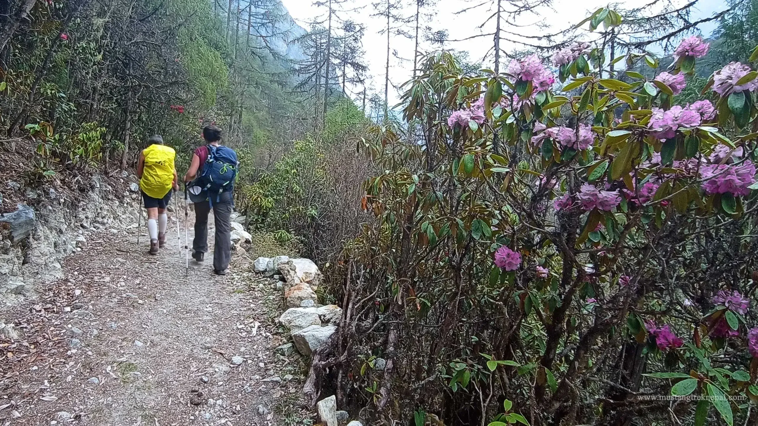
Gyabla to Ghunsa trek distance is about 11.5 kilometers / 7.1 miles. It is a moderate walking trail normally takes around 5 to 6 hours to cross depends on the route and pace. The trail meanders through lush forests of rhododendron, pine, bamboo and alpine meadows. As you ascend, the valley opens up, revealing breathtaking panoramas of snow-capped peaks of Himalayas.
Ghunsa is a beautiful Sherpa village with Tibetan influence. The village provides a glimpse into a traditional way of life and culture where prayer flags flutter in the wind and the aroma of incense fills the air. Ghunsa is the gateway of Kanchenjunga trek in Nepal to explore both base camp (North and south) as well as the base camp of Mount Kumbhakarna.
Ghunsa is a key stop for trekkers to acclimatize before venture towards Kanchenjunga’s base camps. The trek to Ghunsa offers a unique and remote Himalayan experience for nature lovers. - Day 8 : Rest day at Ghunsa for acclimatization and exploration
This is acclimatization day in Ghunsa at an altitude of 3595 meters / 11,794 feet. After breakfast we hike to the view point through lush forests, suspension bridges to avoid the risk of altitude sickness. It serves as a peaceful retreat to rest and rejuvenate before continue further into the Kanchenjunga region Nepal.
Ghunsa is a picturesque Tibetan-influenced settlement’s offers a blend of natural splendor and cultural immersion. Explore the glacial rivers, waterfalls, monastery, village and interact with the locals make the day memorable forever. Kanchenjunga national park is rich in biodiversity, with chances to spot red pandas, snow leopards, blue sheep, black bears, verity of pheasants and many Himalayan peaks etc. - Day 9 : Trek to Kambachen 4050 meters / 13287 feet
Ghunsa to Khambachen distance is a challenging but breathtaking views of Kumbhakarna, other peaks, waterfalls and lush forests make it rewarding. The path is well-defined, first part of the trail is easy and follow Ghunsa Khola river and final part challenging uphill ascend along the edge of glacier to reach Khambachen village. According to the altitude gain, you cross tree line, the landscape transforms into a rugged alpine terrain.
Ghunsa to Khambachen trek distance is 10.5 kilometers and takes 6 to 8 hours depends on walking speed and number of stops. There is only small tea house on the way to Khambachen to take short break, drink tea, refill water or have meals.
Khambachen is a small settlement located at an elevation 4,145 meters. The village surrounded by towering peaks, including majestic Kumbhakarna (Jannu). Khambachen offers basic teahouse accommodation, provides basic amenities, verity of food including local meals. You can have a good time to explore around, interact with local and immerse with awe-inspiring scenery of the Himalayas.
Hiking to kumbhakarna base camp for acclimatization
Kambachen to Kumbhakarna base camp 4540 meters / 14895 feet is a popular side trip for acclimatization. During this journey you can walk through the high-altitude pastures, glacial moraines, rocky trails to reach Phaktanglung temple (base camp). As you climb higher, the landscape transform dramatically and immerse yourself in the raw beauty of Himalayas. Ghunsa to Khambachen is a part of epic Kanchenjunga circuit trek that will leave a lasting impression on your mind.
- Day 10 : Trek to Lhonak 4792 meters / 15721 feet
We will start around 7:30 am for a nice walk up to Lhonak. Khambachen (4,050 m) to Lhonak distance (10 km) is one of the most visually striking and exhilarating sections of Kanchenjunga base camp trail. Journey takes you deeper into the remote northern reaches of Nepal. Trail pass along glacial valleys, ancient moraines, rugged Himalayan terrain, sparse vegetation. It offers jaw-dropping views of the towering Kanchenjunga massif and surrounding peaks.
Khambachen to Lhonak walking path is rocky, uneven, gradual ascent into the thin air along the Kanchenjunga glacier. It requires careful walk, steady and deliberate pace to experience the true sense wilderness adventure.
Ramtang is the place to take short tea break with an amazing view of glacier and epic mountains scenery around. Kanchenjunga base camp route is less crowded compare to other trekking area of Nepal. Trekkers able to sightings the wildlife like blue sheep, Himalayan marmot, red panda, snow leopard in natural habitat into the high Himalayas.
Lhonak situated in a wide, open valley (alpine meadows) surrounded by towering peaks and glaciers. There are basic lodges (seasonally run by locals) and food facility available for explorers. The small settlement of Lhonak appears like an oasis in the glacial desert. Lhonak, at an elevation of 4,780 meters, serves as a high-altitude outpost and a resting point before the final ascent to the base camp. The trek from Khambachen to Lhonak is a challenging yet incredibly rewarding journey that create an unforgettable experience.
- Day 11 : Trek to Kanchenjunga North Base Camp 5143 meters / 16873 feet
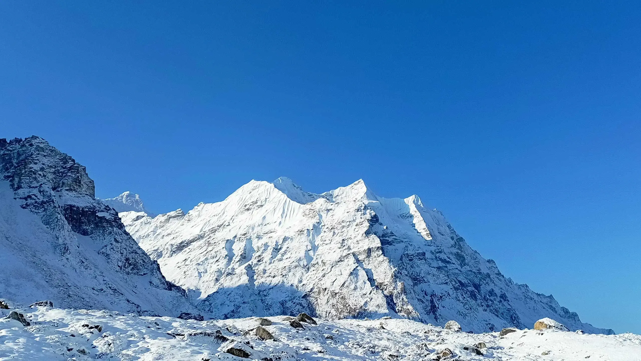
The most awaited day of KBC trip is finally here to reach the base camp of Mount Kanchenjunga the third-highest peak of the world. From the base camp witness stunning views of Kanchenjunga and its surrounding peaks. Early morning hike to Pangpema (Kanchenjunga north base camp 5,143 meters / 16,873 feet).
The route follows the narrow rocky path in high-altitude terrain, glacial streams along Kanchenjunga glacier, with grand views of the Kanchenjunga massif up close (north face). The base camp lies at the edge of the glacier, where prayer flags flutter in the wind, mark the symbolic approach to the sacred mountain. North base camp (Pangpema) offers stunning views of the north face of Kanchenjunga, Yalung, and other Himalayan peaks. The views of icefalls and glaciers cascading down Kanchenjunga, Yalung peak are truly awe-inspiring.Lhonak to Kanchenjunga base camp (Pangpema) distance is 14 kilometers (7 km each way). It takes 7 to 8 hour depends of the walking pace. It immerses you in a high-altitude glacial environment and venture deep into the Kanchenjunga wilderness. Spend some time at the base camp and soak in the incredible scenery. After exploring the base camp of mount Kanchenjunga, you will be back to Lhonak to spend the nights.
Lhonak to Pangpema trek is a thrilling adventure into the heart of the Himalayas. You can spot some wild animals like blue sheep, snow leopards, Himalayan marmots and various bird species in their natural habitat on the way. This remote and challenging journey takes you into the heart of the Himalayas, where glaciers, towering peaks, and untouched wilderness create an unforgettable experience.
- Day 12 : Trek to Ghunsa 3415 meters / 11204 feet
We start our pleasant walk through the alpine meadows with magnificent view of the mountains. The Lhonak to Ghunsa trek is an awe-inspiring journey through pristine landscapes, rugged terrains cover moraine, alpine meadows to dense forest. While descend back to Ghunsa trail winds through diverse ecosystems as elevation declines. Walking trail includes several challenging sections like potential landslide areas, edge of glacier and stream crossings that require careful navigation.
After exploring the north base camp of Mount Kanchenjunga, retrace your steps to Lhonak, then descend to Ghunsa via Kambachen along the Ghunsa Khola. On the way back we stop at Khambachen 4145 meters / 13599 feet for lunch and continue to Gunsa. The journey from Lhonak to Ghunsa distance is 22 kilometers, it requires 7-8 hours of steady trekking to cover. Lhonak located at an elevation of 4,785 meters and Ghunsa situated at the height of 3,415 meters, it means you significantly descent drops nearly 1,400 meters in a single day.
The Lhonak to Ghunsa section of Kanchenjunga circuit trek is the most remote and pristine alpine corridors of eastern Nepal. Embark on this journey to experience the untouched beauty of the eastern Himalayas which reward you with memories that will last a lifetime.a
- Day 13 : Trek to Selele La Camp 4290 meters / 14074 feet
Ghunsa to Selele la camp trek distance is a thrilling and scenic segments of the Kanchenjunga circuit trek in Nepal. It is a high-altitude traverse through coniferous, pine, rhododendron forests, alpine meadows, and rocky terrain. It rewards with spectacular views of snow-capped giants including mount Jannu (7,710 m) of Kanchenjunga national park. Hiking to Selele la camp is a steep and demanding ascent but rewards with diverse ecological experience. The route is far from crowds and offers a true Himalayan adventure.
This route connects the Kanchenjunga north base camp and Kanchenjunga south base camp of third highest peak of the world. It is an opportunity to observe the shifting ecosystems, ancient forests, and windswept alpine ridges up close. Ghunsa to Salele Kharka section is an ideal area to spot Himalayan wildlife including blue sheep, snow leopards, and various high-altitude bird species.
Ghunsa to Selele la camp journey is a dramatic ascent into the heart of the eastern Himalayas. Sele la base camp offers stunning views of Makalu and Everest on clear days. There are 2 tea houses, provides basic shelter and food for trekkers. Selele la camp is not a village but a basic campsite situated at an altitude of around 4,290 meters (14,075 feet). It is a strategic location to spend a night under the stars before crossing the challenging passes.
- Day 14 : Trek to Tseram 3868 meters via Sele La 4645 meters / 15239 feet
Today’s trek takes us over three mountain passes Sele la, Mirgin la, Sinelapche la and offers spectacular views of Kanchenjunga, Yalung Kang and many other peaks. Each pass offers a unique perspective of the surrounding giants. It’s a moment of triumph and mountains view from this vantage point are truly awe-inspiring.
After crossing a series of three high passes trail descend to Cheram a small settlement with teahouses. Tseram village (3,870m) is the gateway to Yalung glacier and Kanchenjunga south base camp nepal. Kanchenjunga circuit trek journey from Selele la camp to Tseram is one of the most challenging and visually stunning segments of the entire expedition.
- Day 15 : Trek to Oktang visit Kanchenjunga South base camp 4,730 meters / 15518 feet
Tseram is one of the best place to wake up early morning with the spectacular view of mountains around you. After breakfast we ascend towards Oktang (south base camp of mount Kanchenjunga). Oktang is the ultimate destination for close-up view of Kanchenjunga massive south face, along with other peaks like Yalung Kang, Kabru (7,353m), Rathong (6,678m), and Koktang (6,147m). The viewpoint sits near the Yalung Glacier, adding to the dramatic landscape.
Tseram to Oktang trek is a high-altitude journey along the glacial valleys. It takes you deep into the heart of third highest peak, offers breathtaking adventure in most remote alpine zone of Himalayas. The air is crisp, the silence is profound, and the scale of the mountains becomes awe-inspiring. Tseram to Oktang trek typically requires 6-7 hours to cross 10 km of distance. Ramche is a small settlement near the Yalung Glacier. Local teahouse provides basic food and place to sleep for travelers.
Oktang viewpoint or south base camp of mount Kanchenjunga. There is a small Hindu and Kirat shrine marks the viewpoint, adding a spiritual touch to the experience. Spend time soaking in the panoramic vistas and capturing photos of the snow-clad peaks and glaciers. After exploring base cap trekkers back to Teram or spend the night at Ramche. Every step reveals the raw majesty of the Kanchenjunga region. Proper planning, reliable guide and a passion for adventure make this trek memorable that will last a lifetime.
- Day 16 : Trek to Tortong 2980 meters / 9776 feet
Typically, Rimche to Tortong distance spans 7 to 8 hours of walking and covers a significant descent from the high elevations of Kanchenjunga base camp south to lower valleys. During this 17 kilometers of walk trekkers get an opportunity to explore diverse ecosystems, unique flora and fauna (glacier, alpine meadows to subtropical dense forest). It helps to observe Himalayan ecology, how vegetation adapts to different altitudes and climate conditions.
Rimche to Tortong trek is a moderate level of hiking, but the significant downhill can be demanding for the knees. It’s a day that requires attention to the trail, which can be rocky and uneven in places. KBC trail winds through dense rhododendron forests, it particularly spectacular during spring (blooming season), when vibrant red, pink, and white flowers create a natural wonderland.
Tortong, situated at an altitude of 2,995 meters. It is a small settlement with basic teahouses run by local Sherpa and Limbu communities. It serves as a rest stop and an overnight halt for trekkers. Embark on Rimche to Tortong trek journey to discover the raw beauty and wilderness of Kanchenjunga national park in eastern Nepal.
- Day 17 : Trek to Yarsang 2145 meters / 7037 feet
Today we head off for long descent to Yarsang village through subtropical forests. Tortong to Yarsang trek distance is a scenic and less-traveled segment of epic Kanchenjunga circuit trek in eastern nepal. The Tortong to Yarsang section offers real test of peace and wilderness. It is ancient walking path of local but recently introduced path between tourists. Tortong to Yarsang distance is 12.5 kilometers. It takes 5 to 6 hours to reach Yarsang from Tortong (depends on walking speed) following pristine valleys of the Simbuwa Khola.
Trail pass along the tranquil river, pristine forest of bamboo, rhododendron, pine, oak, larch etc. Where you can encounter wildlife, feel the raw Himalayan beauty, complete solitude and deep connection with nature.
Yarsang is a new and small hamlet with a few basic lodges, offers a cozy respite after the high-altitude sections of Kanchenjunga base camp trek. There are 2 teahouses in Yarsang run by local family to host the trekkers. They offer simple meals and sleeping space.
Tortong to Yarsang route travers’s multiple ecological zones, provide exceptional opportunities to observe how flora and fauna adapt to different elevations and climate conditions. The changing vegetation zones serve as a natural classroom for understanding Himalayan ecology and the complex relationships between altitude, climate and biodiversity.
- Day 18 : Trek to Zero Point 1750 meters / 5741 feet then drive to Taplejung
Today is your final day of epic Kanchenjunga circuit trek journey. We walk about two hours to reach zero point to catch the jeep to Taplejung bazaar. The road distance is 30 kilometers and takes time 2 to 3 hours. This part of the trek provides an opportunity to observe nature, culture and authentic way of life in the Himalayan foothills. As you trek towards Ranipul, Tamewa, you may encounter local villagers working in their fields and glimpse into the daily lives of mountain people. The route is less frequented than other parts of the circuit, earning it the nickname “local trail” as opposed to a “tourist trail.”
- Day 19 : Drive to Biratnagar 80 meters / 262 feet and Flight to Kathmandu
Today is the end of adventure “Kanchenjunga base camp trip” in eastern Nepal. We drive from Taplejung to Biratnagar via Tamar corridor. It is one of the most efficient ways to travel to connect eastern hills to Terai (plains). It covers about 185 kilometers and takes around 7 to 8 hours (some parts still ongoing construction). Tamor corridor reduce the travel time compare to Mechi highway and connect remote mountain regions. This highway offers scenic view of high mountains, hills, valleys, rivers, terrace field including Dharan city of Nepal.
Tamor corridor is an alternative route to connect Taplejung to Terai, following the Tamor river valley. The first part of the road is hilly, narrow, and occasionally rough until Phidim. Second part Tamor corridor mostly paved, some gravel/dirt sections. Final part is Dharan Dhankuta road is well-maintained highway until Biratnagar. It is long drive through scenic landscapes, as soon as you reach Biratnagar one can flight back to Kathmandu or rest and relax at hotel.
- Day 20 : Airport transfer to depart Nepal
Embark on your final day of journey! Three hours before the scheduled flight, we will escort you to international airport for final departure.
“Have a safe flight! May your journey be free from stress and bring you home safely.”
Trip Cost Inclusion
- Airports pick up on your arrival day by private vehicle
- Kathmandu sightseeing as per the itinerary
- Round trip flight from Kathmandu - Bhadrapur - Kathmandu
- Transportation from Bhadrapur to Taplejung trek start point
- 3 meals (Breakfast, Lunch & dinner) 4 cups of hot drink each day on choice
- Normal tea houses / camping tent accommodation during KBC trekking period
- Professional English speaking guide trained by government of Nepal
- Experience trekking staffs (2 guest = 1 porter basic) to carry your backpack
- All necessary paperwork, special permits, TIMS and local taxes
- Travel and rescue arrangements if require
- Drop you to airport by private vehicle to depart Nepal
Trip Cost Exclusion
- Visa fees / international airfare to and from Kathmandu
- Hotel, Lunch and dinner in Kathmandu
- Personal expenses phone calls, mineral water, bar bills, hot shower, battery recharge, extra porters & gears etc
- Tips for guides, porters (Tipping are expected but not mandatory)
Gallery